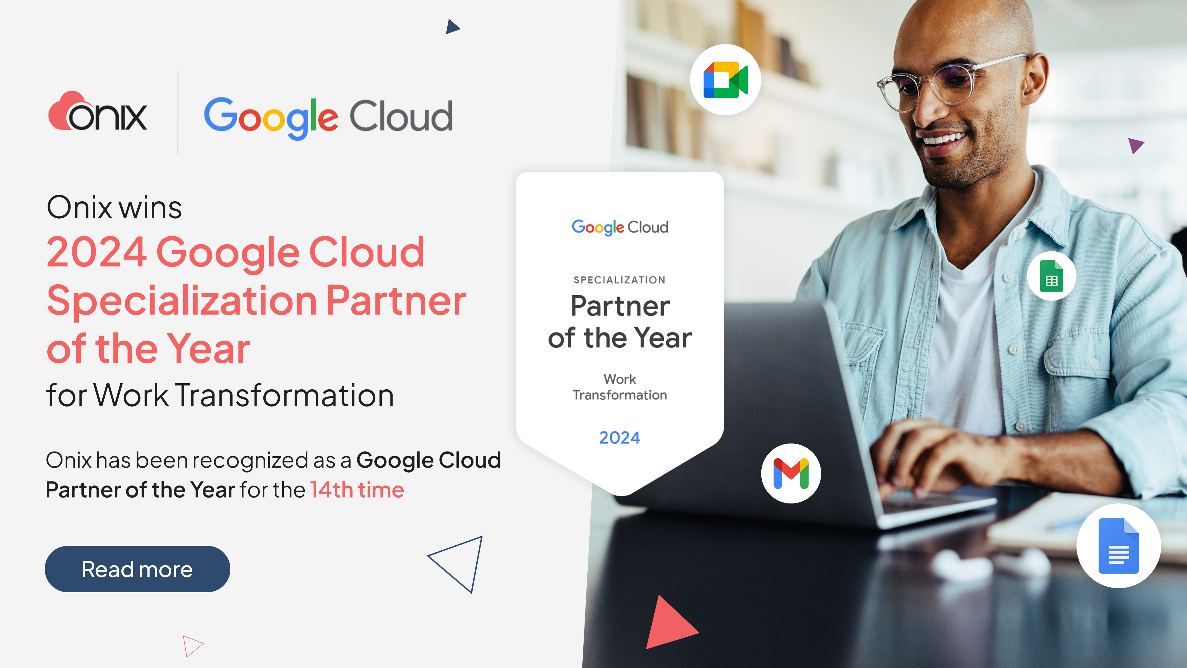
Onix

Google Earth

Make it easy for your employees to view understand and make decisions about location based information.

Google Earth and Maps for business combine the familiar, interactive Google mapping products with added features designed especially for business users.

Google Earth Enterprise

Make your organization's imagery, aerial photography and other geospatial data accessible and useful to all employees who need access. This secure version of Google Earth runs in your organization's own data center utilizing your own data.

Google Earth Enterprise allows you to synthesize terabytes of imagery, terrain and vector data to make a quick mapping application for your users.

Enterprise ready mapping solution

Safe and Secure

Create custom layers for Google Maps or Google Earth with private data and limit use to only a department or an organization. Leverage the same security you already have in your current organization with data that resides entirely on-site.

Portability

View your custom map layers on the go - even when connectivity is lacking - with the Google Earth Enterprise Portable solution.

Usability

Google Earth Enterprise creates map layers with private data, viewable on Google Earth and Google Maps. Any employee who is familiar with Google Earth or Maps can view your organization's data - without worrying about learning a new software program.

Controllable Data

Manage how your data is viewed by your users with control over everything from color and visibility, to the attributes exposed in the pop-up bubbles. Updates to your sensitive data remain in your organization's hands.


Empower GIS analysts

Create interactive maps for all employees to use - freeing up time for GIS analysts to analyze data and complete research instead of creating maps. Google Earth Enterprise allows your technical staff to spend more time on analysis by giving non-technical staff Google Earth as a visualization tool.


Enterprise software features

Google Earth Enterprise is comprised of two distinct software packages that work together to build and host your private Google Earth and Google Maps layers. End users then view the complete Google Earth and Maps in the Google Earth Enterprise Client or in a browser like Google Maps.

  • Google Earth Enterprise Fusion combines all of your imagery, terrain, KML, and vector data into a Google Earth globe or a Google Map.
  • Google Earth Enterprise Server Software allows you to host your private or public globe or map for your users to access via Google Earth client or a Google Maps browser.
  • Google Earth Enterprise Client is like the familiar Google Earth client – with more than 700 million downloads worldwide – but offers your users an easier way to view geospatial data over traditional desktop GIS software.
  • Google Earth API gives your users the best of both worlds - allowing them to easily view your organization's data within a custom browser experience created by your developers.

Google technology for your geospatial data

Google Earth Enterprise uses similar processing and serving infrastructure that's used at Google to build and serve Google Earth and Google Maps to millions of users and brings it to your organization's data, allowing rapid and secure viewing. Web-based maps mashups can be easily built with your data through Google Earth Enterprise and data is securely viewable and accessible through the Google Earth Enterprise client or through a browser using the Google Earth or Google Maps API.

Industries

Google Earth Enterprise powers geospatial visualizations in multiple industries. Add Earth Enterprise to your GIS workflow, and make informed geographic decisions.
 

Retain legacy GIS systems

Google Earth Enterprise works with the data from various Geographic Information Systems, to provide fast, visualization tools to employees.


Energy and Utilities

Manage large infrastructure projects from afar with Google Earth Enterprise.

Whether your coverage area spans multiple states or just a couple of square miles within a city, your infrastructure is vital to creating, transporting and supplying energy, fuel and water. Combine your mapping data in Google Earth Enterprise to monitor your territory from your desk.

Grow customer connections

Provide customers information on outages, service area, new infrastructure projects all combined with your recent imagery acquisitions and geographic data streams.

Track projects

From pipeline building to substation maintenance, gain situational awareness of large infrastructure projects regardless of location, without the added travel costs.

Respond to outages

Using the portable and mobile components of Google Earth Enterprise, energy and utility companies can respond to outages on the fly even if the location is without internet connectivity.

Prepare for weather or emergencies

Overlay weather data streams to visually analyze and plan for bad weather that might require increasing electricity production or closing pipelines.


Federal - Civilian

Add value to your GIS investments by making the geospatial data available to anyone in your organization with Google Earth Enterprise.

Leverage similar technology used to create Google Earth for millions of people with Google Earth Enterprise. Whether an environmental agency needs to track animal migration or monitor funds used over time within a particular geography, Google Earth Enterprise provides the most comprehensive tool to scale geographic data beyond the GIS department.

Massive data consolidation

Within an organization, multiple departments might own and license geospatial data. Bring together all your data into one place, with one intuitive, easy-to-use way to access it.

Scalable to multiple agencies

Terabytes of imagery and vector data from one agency or multiple organizations can be combined into a fast and fluid mapping application using Google Earth Enterprise creating a common operating picture.

Simple user interface

Make GIS novices able to view geospatial data like professionals. Superior ease of use allows virtually anyone to view, grab, pan, and zoom through earth imagery and GIS data in seconds providing necessary resources to police, emergency professionals and policy analysts.


Federal - Intel


Use Google Earth Enterprise to create fast, effective geographic visualizations for mission critical operations.

Provide multiple agencies with the geographic information needed to make decisions on the fly without wasting time compiling datasets across agencies. With Google Earth Enterprise, intelligence organizations can use existing GIS data to provide faster, better access to more people.

Secure and disconnected from internet

Manage your instance of Google Earth Enterprise as connected or disconnected from the Internet. In addition to office-based map viewing, the Google Earth Enterprise Portable solution offers in-field access to key points and imagery without internet access.

Streamlined delivery of mission critical data

With Google Earth Enterprise, you no longer have to search and compile mapping data after emergencies. Respond quickly to current events with custom map layers on Google Earth or Google Maps for fast deployment of geospatial data.

Collaborate across agencies

Reduce the time spent on securing data from multiple agencies. Multiple agency datasets can be combined to create a common operating picture using Google Earth Enterprise.

Google Earth Enterprise and GIS

Companies and governments have large GIS investments so make these investments more useful to all employees - regardless of technical ability - with Google Earth Enterprise.