
Whether it’s for delivery services, navigation, or real estate applications, accurate and detailed data is key to enhancing user experience. Google Maps Platform has again raised the bar by introducing building outlines and entrances as part of the Geocoding API.
This new feature promises many benefits that can make geospatial applications even more powerful. Let’s dive into what makes Building Outlines and Entrances a game changer for developers and organizations.
What are Google Maps’ Building Entrance & Outline features?
As the name suggests, the Building Entrance & Outline enhancement in Google Maps’ Geocoding API provides the specific location of any building or facility entrance. The Outline enhancement displays the shape and location of the building – and its position relative to surrounding buildings.
The obvious benefit of this feature is to navigate the Google Maps user to a precise location of entry, thus saving their journey time.
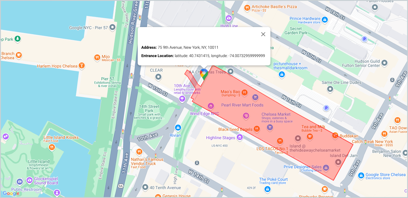
Here’s a real-life example of the Manhattan-based Google office using a building entrance feature:
6 Benefits of Google Maps’ Building Entrances & Outlines
- Enhanced precision of the target address
Google’s Geocoding API is designed to improve address-related information for accuracy and precision. The Building Entrance & Outline feature is a valuable enhancement to Geocoding API by visually displaying the exact shape and position of the structure.
For example, Maps users can now see the exact footprint of the building – instead of its general location. Through property visualization and space planning, they can reach their destination faster and without hassle. - Finding the right building entrance
For logistics companies and delivery services, it’s often cumbersome to find the exact entrance to a building or property. This is most relevant in large-sized facilities like shopping malls, corporate office buildings, and large residential complexes.
With Google Maps’ Building Entrance functionality, they now have the exact location of the building entrance, thus saving both time and effort. - Improved user experience
The Building Entrance & Outline functionality in location-based applications can elevate the user experience. When navigating any complex environment, users can use this functionality to:
- Remove any guesswork from real-world navigation.
- Plan their journey based on the exact dimensions of the building, entrance, and the most efficient road access.
- Enhanced location-based services
The Building Entrance and Outline feature can seamlessly work with Google Maps’ other location-based features such as:
This integration benefits companies that depend on Google Maps’ location-based services by providing their customers with complete information about the target area or location.
- Routes API that can optimize the delivery schedule
- Places API that provides the additional context of the desired location
- Streets View provides an enhanced visual view of the surrounding street
This integration benefits companies that depend on Google Maps’ location-based services by providing their customers with complete information about the target area or location.
- Improved building security
With Google Maps’ Building Entrance and Outline feature, security teams or professionals can plan their building safety by enabling surveillance and access control at the right entrance. By accessing the exact building footprint and entrances, they can easily secure the various entry points and access routes to the building.
This level of surveillance coverage is critical in large and sensitive facilities.
- Smart city planning
Smart cities and IoT applications depend on precise location-related data. With the Building Entrance and Outline facility, city planners can use real-time location data to design them:
- Modern parking facilities
- Emergency response applications
Real-life applications of Google Maps’ Building Entrances & Outlines
Here are some of the real-life applications of these new features:
- Delivery services
In densely populated and congested cities, delivery service executives find it challenging to find the exact location of a building entrance. With this functionality, they have a visual cue to the building, thus navigating to the right location. This saves them a lot of time and hassle in finding their customers. - Real estate and urban planning
Before this latest enhancement, real estate developers could only mark their residential or commercial property with a pin on the location. With the Outlines functionality, they can present the complete layout of their property – including the dimensions. - Security and Compliance
Building security companies can leverage this Google Maps enhancement to monitor building premises and entry points. With real-time data, they can ensure continuous control over building entrances or exits.
How to add the Building Entrance and Outline feature
Google Maps developers can enable this functionality in their Geocoding API by simply adding the following highlighted code to the Geocoding request:
Conclusion
With Google’s new Building Entrance and Outline feature, you can improve your location-based services and enrich your customer experience.
With its expertise as a Google Maps reseller, Onix can help you integrate this functionality into your location-based services. If you want to know more, contact our team today.